Udenrigsudvalget 2009-10
URU Alm.del
Offentligt
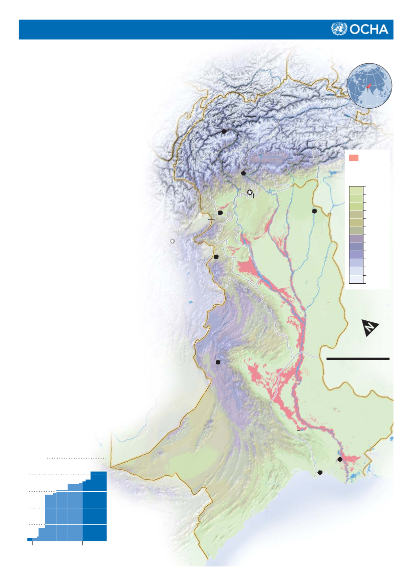
Pakistan Floods:Timeline of Events
(as of 17 September 2010)
More than 20 million people affected since July22 July 2010:Dozens of people are killed and tens ofthousands displaced following heavy rains acrossBalochistan, Punjab and Khyber Pahktunkhwa.29 July:Flash floods and landslides devastate largeparts of Khyber Pakthunkhwa, smaller areas ofthe Federally Administered Tribal Area, GilgitBaltistan and Pakistan-Administered Kashmir.According to the Government, more than 800people died and millions may be affected.6 August:Pakistan declares a red alert asfloods reach southern provinces. Hundredsof thousands of people are evacuated.7 August:Landslides and flash floods arereported in Gilgit-Baltistan and other parts ofnorthern Pakistan. Floods move into Sindhand Balochistan.11 August:The Pakistan Initial FloodsEmergency Response Plan requests $459million for relief assistance for an initial threemonths.CHINAPakistan
Gilgit
Jammu-KashmiJammu-KashmirJammu-Kashmir
KHYBERPAKHTUNKHWA
MuzaffarabadMuzaffarabadIslamabadISLAMABAD
FloodextentElevationin meters02004006008001,0001,5002,0002,5003,0004,0005,00025,000
PeshawarFEDERALLYADMINISTEREDTRIBAL AREAS
Lahore
15 August:United Nations Secretary-General BanKi-moon visits flood-affected areas.25 August:More than 800,000 people are cut off byfloods. The United Nations requests more support forhelicopter missions.26 August:A breach develops on the eastern bank ofthe Indus River in Thatta district. Thatta city is officiallyevacuated as the Indus breaches its western bank inthe south.30 August:At least 1 million people are reportedlyon the move in Sindh as villages are submerged.7 September:United Nations Emergency ReliefCoordinator Valerie Amos arrives in Pakistan for athree-day mission.13 September:Manchar Lake overflows, floodingnew areas in Sindh’s Jamshoro district.17 September:A revised Floods EmergencyResponse Plan requests $2 billion for reliefand early recovery needs for 12 months.Estimated number ofaffected people25 million20151050Aug.Creation date:17 Sep 2010Feedback:[email protected]
MiramShah
P U N J A B
B A L O C H I S T A N250 km
Insdu
INDIA
Quetta
STAN
AFG
HA
NI
P
A
K
I
S
TSI
ANDH
N
MancharLake
ThattaKarachi
ISLAMICREPUBLICOF IRAN
ArabianSea
Sept.Glide number:FL-2010-000141-PAKhttp://ochaonline.un.org/pakistan www.reliefweb.int
The boundaries and names shown and the designations used onthis map do not imply official endorsement or acceptance by theUnited Nations. Dotted line represents approximately the Line ofControl in Jammu and Kashmir agreed upon by India andPakistan. The final status of Jammu and Kashmir has not yetbeen agree upon by the parties.
www.pakresponse.info

